A powerful cold front combined with tropical moisture is causing heavy rains and flash flood risks across the Southeast, particularly in the Carolinas and Georgia, with potential for isolated 3-5 inch rainfall amounts, and the threat of tropical development remains low but possible.
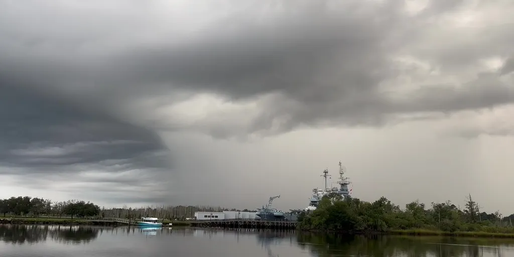
The National Hurricane Center is monitoring a cluster of thunderstorms off Florida's coast for potential tropical development as it moves into the Gulf, with increased rain and thunderstorms expected in North Florida, including the Panhandle, regardless of whether a storm forms. Residents are advised to stay updated on the forecast.
The National Hurricane Center is monitoring an area off the Southeast Coast for potential tropical development in the 2025 hurricane season, with a low chance of formation but expected heavy rain and rough surf from Florida to the Carolinas over the next few days, which is typical for this time of year.
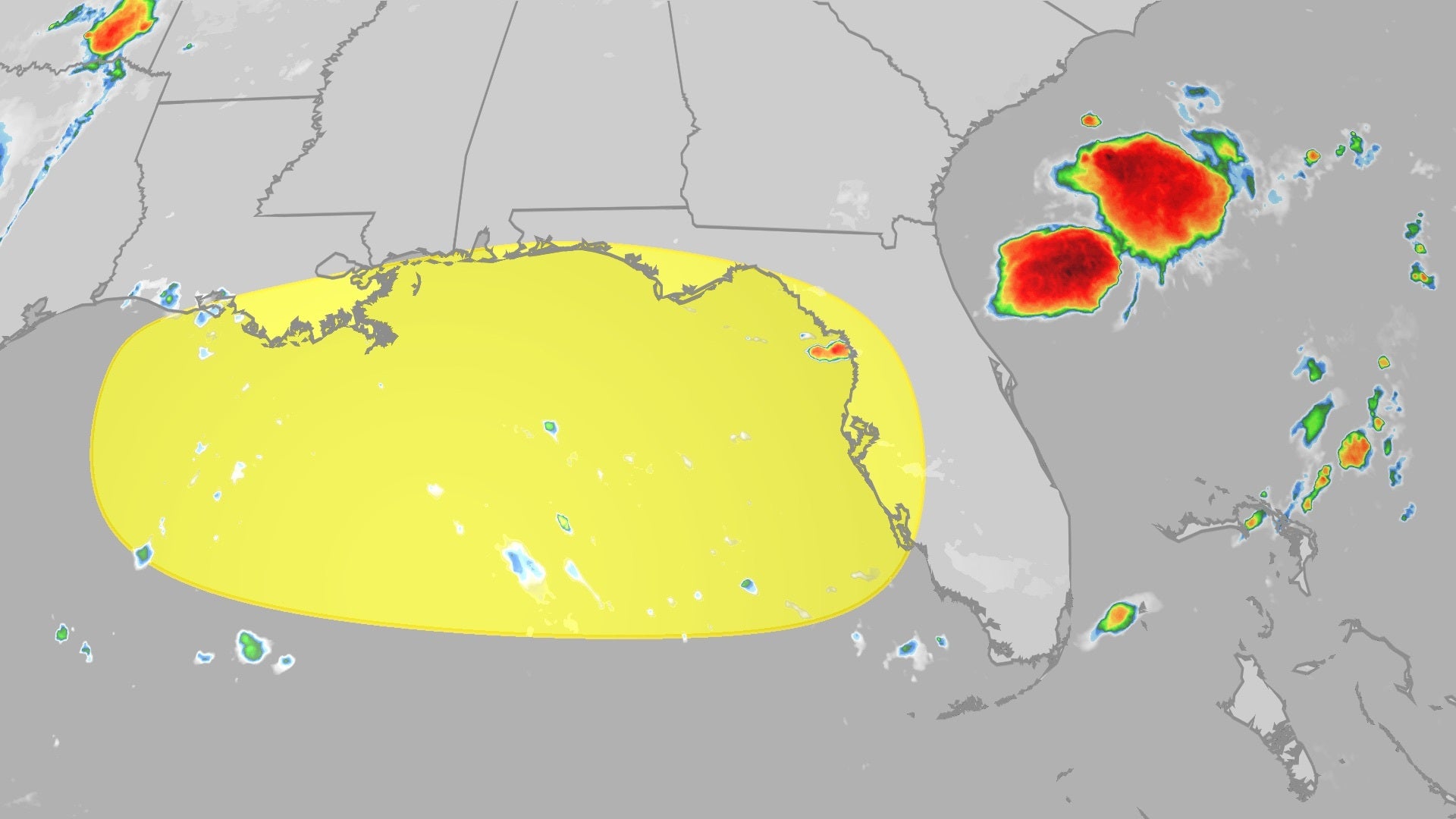
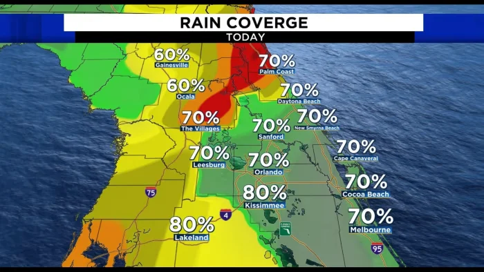
Florida will experience continued heavy rain and thunderstorms this week as a stationary front remains over the state. Forecasters are also monitoring the potential for tropical development off the southeastern coast of the U.S. Regardless of tropical development, the area of disturbed weather will bring several inches of rain, gusty winds, and the risk of coastal flooding from Florida to the Carolinas and into the mid-Atlantic states. Inland areas of Florida could see 1 to 2 inches of rain, while coastal areas may experience higher totals. Residents in the Southeast should also prepare for strong winds and potential coastal flooding.
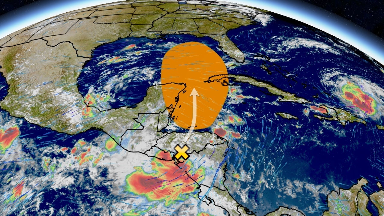
An area of low pressure in the northwest Caribbean or eastern Gulf of Mexico could potentially develop into a tropical depression or storm this weekend into early next week. If a system forms, it is likely to track towards Florida, although the impacts are uncertain. Wind shear is currently high, hindering tropical development, but conditions may become more favorable in the coming days. Floridians are advised to stay updated on the forecast changes and review their preparation plans as we enter the peak of hurricane season.
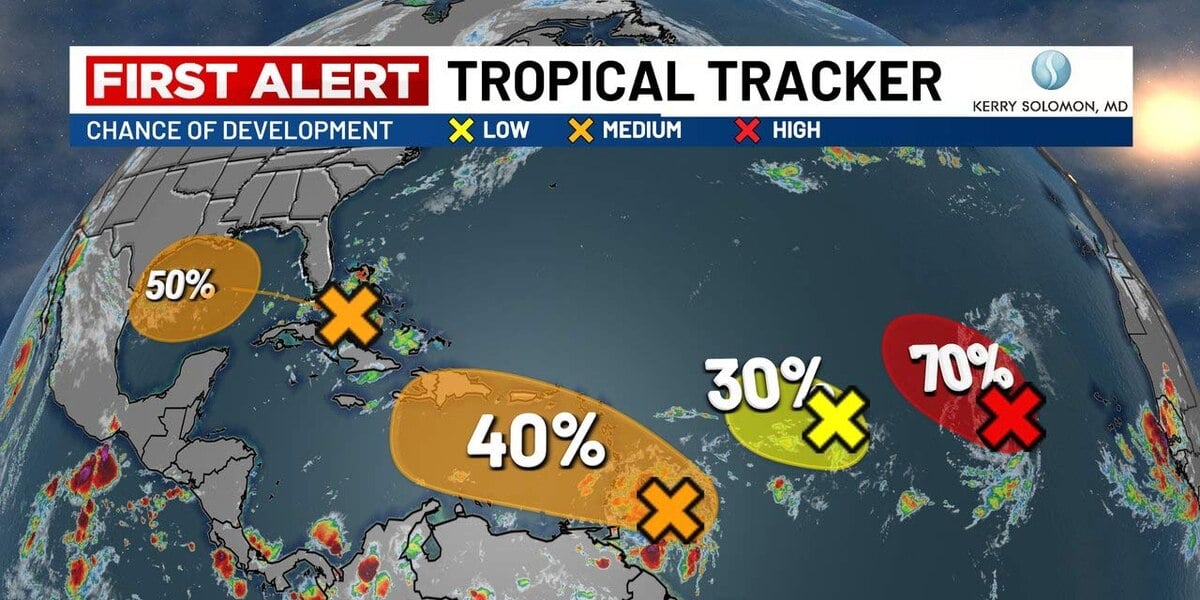
The National Hurricane Center is monitoring a tropical wave over Florida and three disturbances in the Atlantic as the peak of hurricane season approaches. The closest system to the Lowcountry is a tropical wave near the Bahamas, which is expected to move across Florida and into the Gulf of Mexico. Another disturbance west of the Cabo Verde Islands has a high chance of development, while two other systems closer to the eastern seaboard have lower chances. Meanwhile, Hurricane Hillary, a Category 4 hurricane, is expected to bring heavy rain to parts of California.
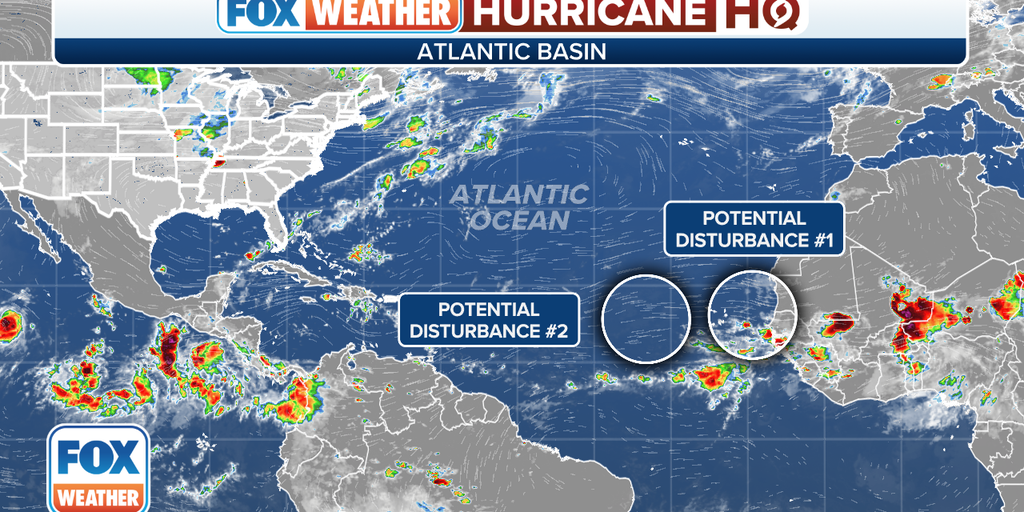
The National Hurricane Center is monitoring two areas in the Atlantic for potential tropical development. The first area, located in the Eastern Tropical Atlantic, is a broad area of low pressure expected to develop between the Cabo Verde Islands and the west coast of Africa. The second area, located in the Central Tropical Atlantic, is another area of low pressure that could develop over the east-central tropical Atlantic. Despite a quiet period in the Atlantic, forecasters expect August to be more active for tropical cyclones.
Scattered storms are expected in Central Florida, with the potential for locally heavy rain, frequent lightning, and strong wind gusts. Temperatures will be hot and humid, reaching the 90s with heat index values in the triple digits. Rain chances will remain moderate to high throughout the week. In the tropics, an area of showers and storms in the central Atlantic is expected to become a tropical depression next week, but it poses no threat to Florida.
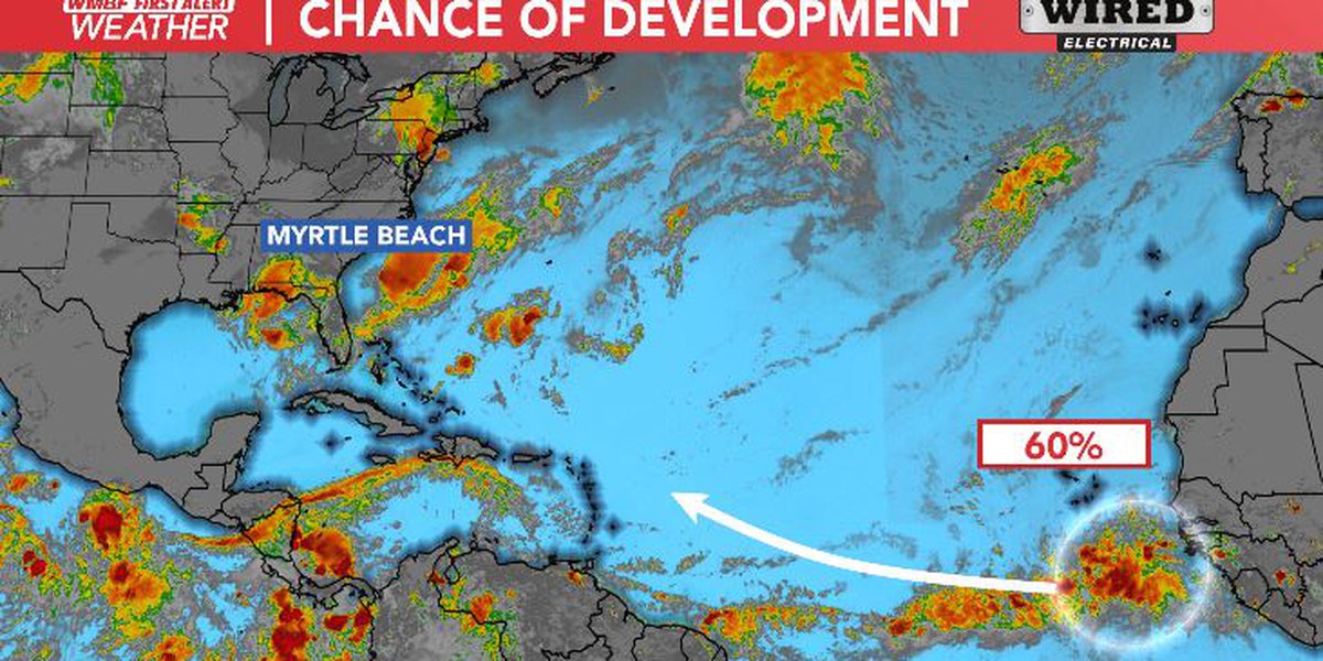
Invest 92-L, located southwest of the Cabo Verde Islands, has an 80% chance of developing into a tropical depression over the next seven days, according to the National Hurricane Center. There is no current threat to Florida.
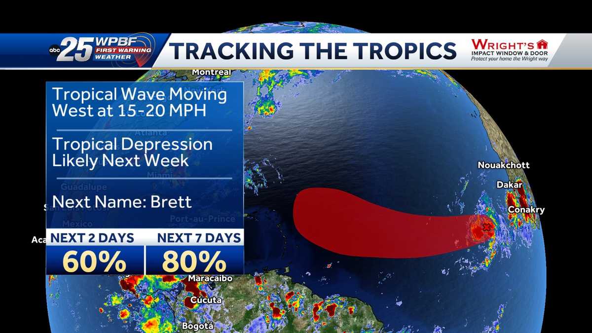
An area of developing low pressure near the coast of Africa is being monitored for potential tropical development over the next several days. The National Hurricane Center reports that a tropical depression could form during the early to middle portions of next week while the system moves westward at 15 to 20 mph across the eastern and central tropical Atlantic. The chance of development is now at 60%.
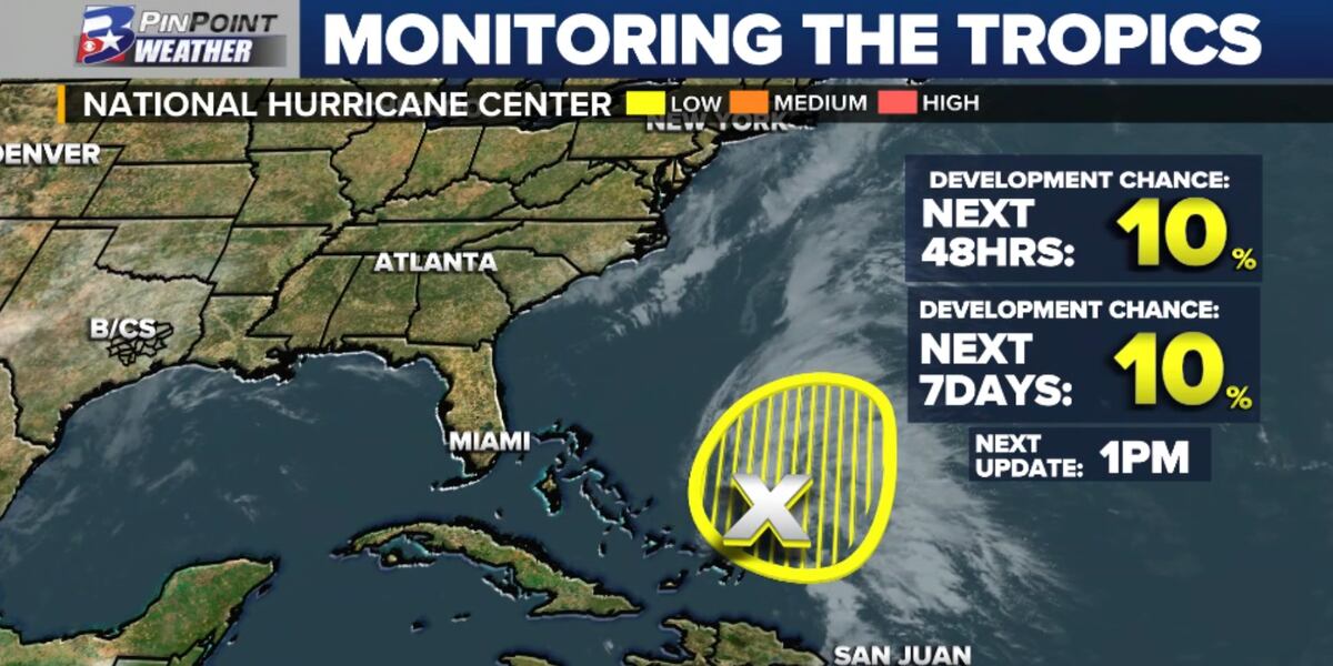
The National Hurricane Center has tagged the first "area of interest" of the Atlantic hurricane season near the Bahamas, with only a 10% chance of development due to hostile upper-level winds. The agency is now issuing tropical weather outlooks up to seven days, an increase from five days in previous seasons.
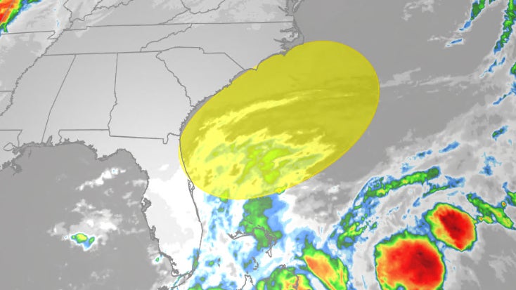
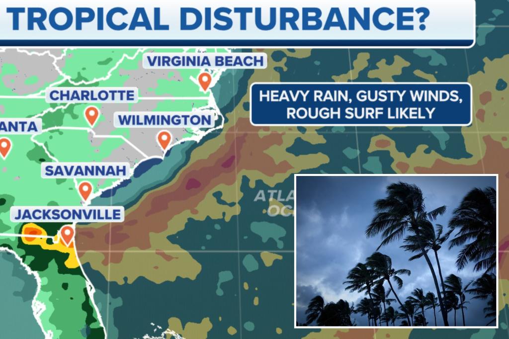
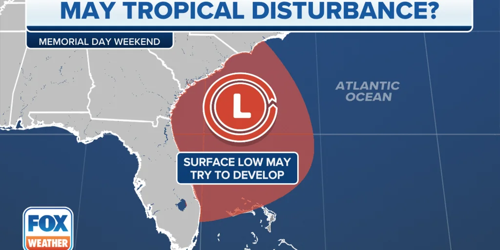
A complex weather scenario off the Eastern Seaboard through the Memorial Day weekend could lead to a tropical disturbance developing over the western Atlantic. A cold front will stall over Florida, while spin develops in the upper levels of the atmosphere, leading to a period of heavy rain, rough surf, and gusty winds impacting coastal areas. The combination of gusty winds and rough seas is expected to lead to an enhanced threat from rip currents that could stretch from the Carolinas through the Sunshine State into the Memorial Day weekend. If development happens over a warm pool of water, it is within the realm of possibility that a weak tropical feature could develop off the Southeast coast.
The National Hurricane Center is monitoring a disturbance near the Bahamas for possible tropical development off the Southeast coast by Memorial Day weekend. A cold front stalling over Florida and spin developing in the upper levels of the atmosphere could lead to heavy rain, rough surf, and gusty winds impacting coastal regions of the Southeast. Even if tropical development doesn't occur, some Florida communities are expected to receive between 3 and 6 inches of rainfall. The disturbance near the Bahamas currently has a 10% chance of development into a tropical depression.