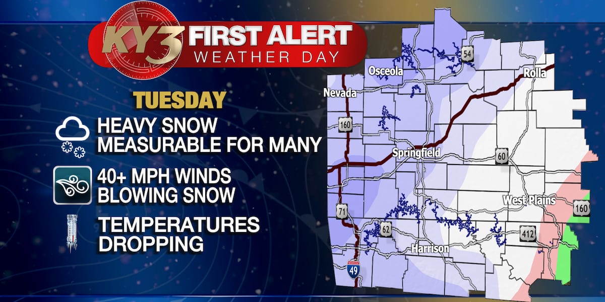
The Ozarks region experienced cold and cloudy weather with some snow showers, but Sunday is expected to be sunny with temperatures rising to the mid to upper 40s. A new storm system will bring rain on Monday, turning to snow with gusty winds on Tuesday, leading to a First Alert Weather Day. Snow accumulations will vary, with 1 to 3 inches expected in Springfield and up to 6 inches northward. Temperatures will remain below normal through the next week, with another potential storm system by next Friday.
The rainstorm, accompanied by a wintry mix in the higher northern and western suburbs, is expected to clear out early this evening, with winter weather advisories in effect for parts of Virginia and Maryland. Temperatures are currently mild but will drop to the low-to-mid 30s overnight, with winds helping to prevent icy conditions. The following day will be cloudy and breezy with a slight chance of showers and gusty winds, while temperatures will peak in the mid-to-upper 40s. The National Weather Service is scaling back on weather alerts as the storm moves out quickly this evening.
The India Meteorological Department (IMD) has issued a 'cold day' alert for several states in North India, predicting temperatures to fall below 10 degrees Celsius. Dense fog is expected to continue in the northwest region during nights and mornings for the next two days. Cold conditions have been reported in Haryana, Rajasthan, Punjab, and isolated areas in Delhi and North Madhya Pradesh. Delhi and other cities have recorded significantly lower maximum temperatures than usual. Dense fog is also forecasted for other regions, including Uttar Pradesh, Bihar, and northeastern states, with isolated light rainfall expected in northwest and central India from January 8 to 10.
The weather forecast indicates a mostly cloudy Thursday with a few scattered snow showers, particularly in northern areas and across the mountains, with gusty winds making temperatures feel cooler. Highs will reach the upper 30s before dropping in the evening. Friday will be sunny and brisk, leading to a quiet start to the weekend. However, a potential storm late Saturday night into Sunday could bring the first widespread snow of the season, with the storm's track determining the snowfall amount and impact. Weather updates will become more certain as the week progresses.
Louisville is set to experience a shift in weather as a system from the southwest brings rain on Friday night, which is expected to turn into snow by Saturday morning due to a drop in temperature from northern cold air. The snowfall is likely to result in minor accumulations, especially north of Interstate 64, with Saturday's highs struggling to rise above the 30s. Conditions will improve slightly on Sunday with a transition back to light rain and drizzle as temperatures warm into the 40s. The forecast will be updated as new information becomes available.
Michigan is set to experience a return of snow showers on New Year's Eve after a mostly snowless December. Temperatures will be milder than average but cooler than recent days, with lows in the 30s across the Lower Peninsula and mid to upper 20s in the Upper Peninsula. Light snowfall is expected throughout the day, with less than an inch of accumulation in northern Lower Michigan. Evening celebrations are likely to be chilly with temperatures dropping after sunset, but the weather will remain relatively calm, allowing for outdoor New Year festivities.
As New Year's Eve approaches, the weather forecast indicates a shift from rain to sunshine at the start of the weekend, followed by the return of snow showers by the end of the weekend. Temperatures are expected to drop to the lower 40s on Saturday and then to the upper 30s on Sunday, with little to no snow accumulation. The start of 2024 will see mostly cloudy skies with temperatures remaining in the upper 30s, and the weather pattern of clouds and occasional snow showers is expected to continue into the middle of next week.