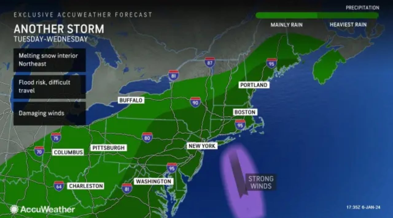
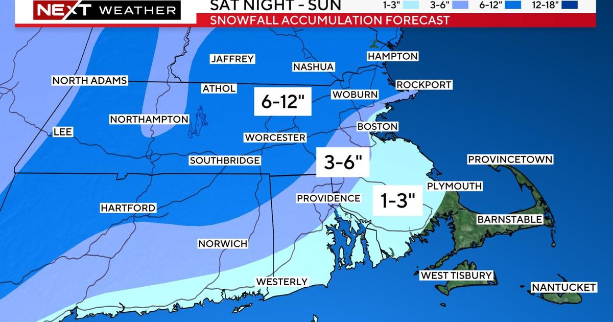
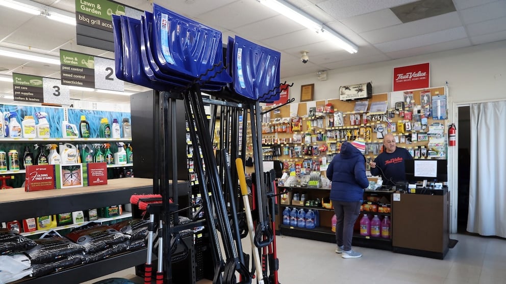
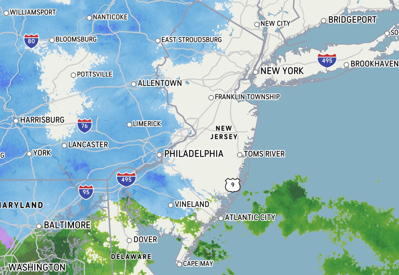
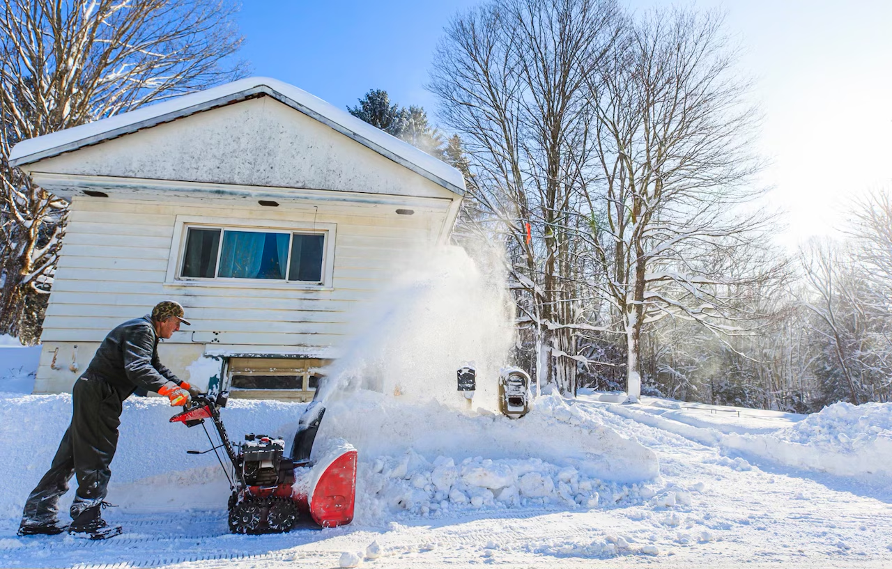
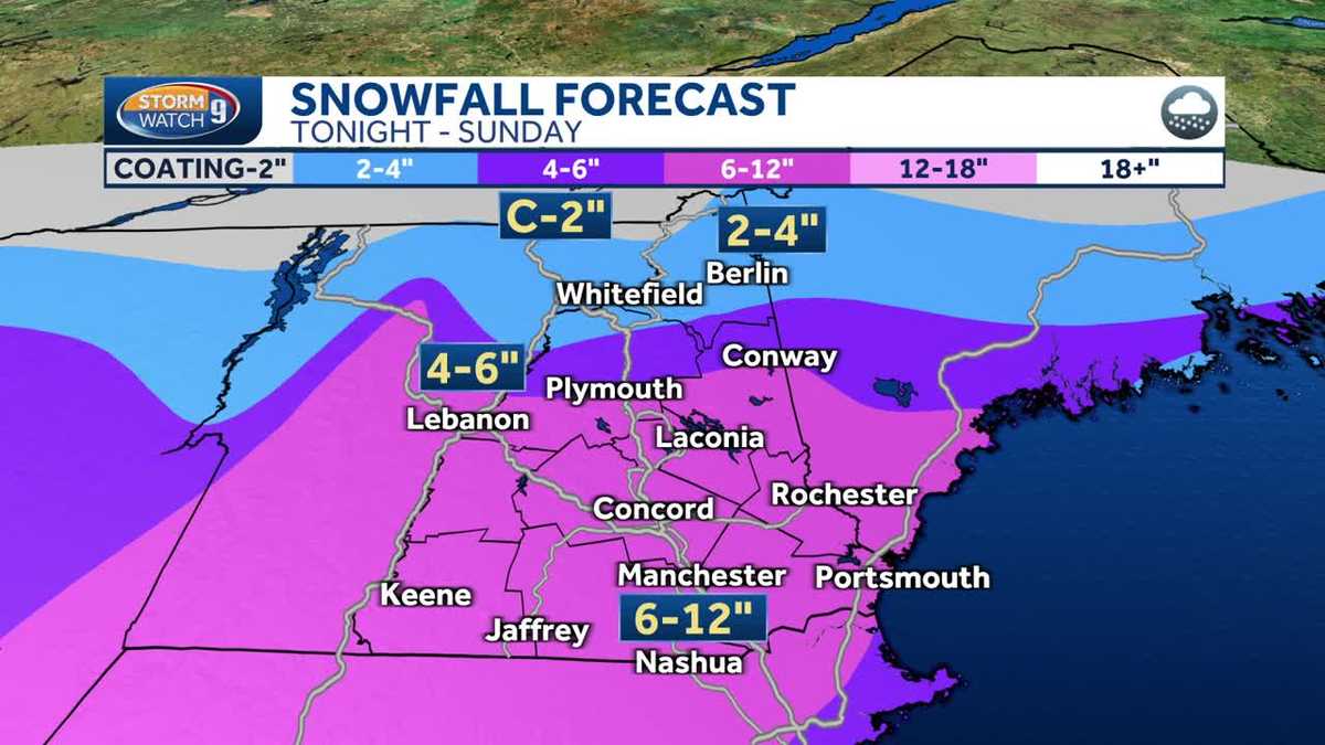
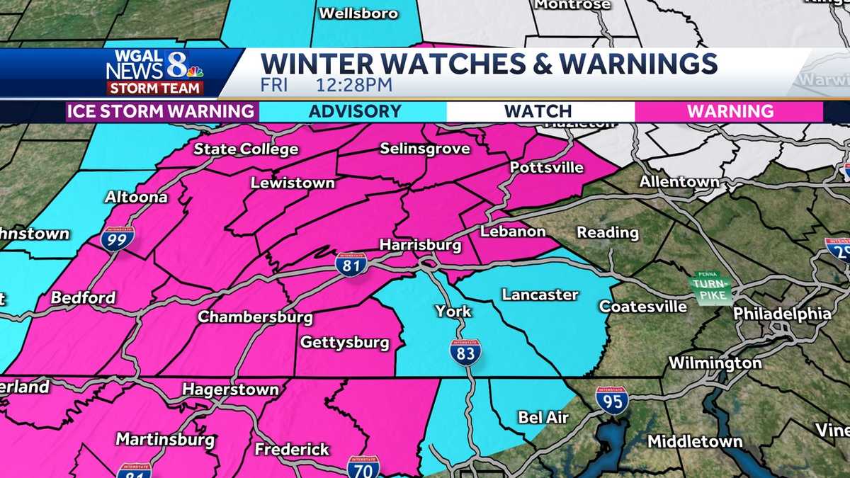
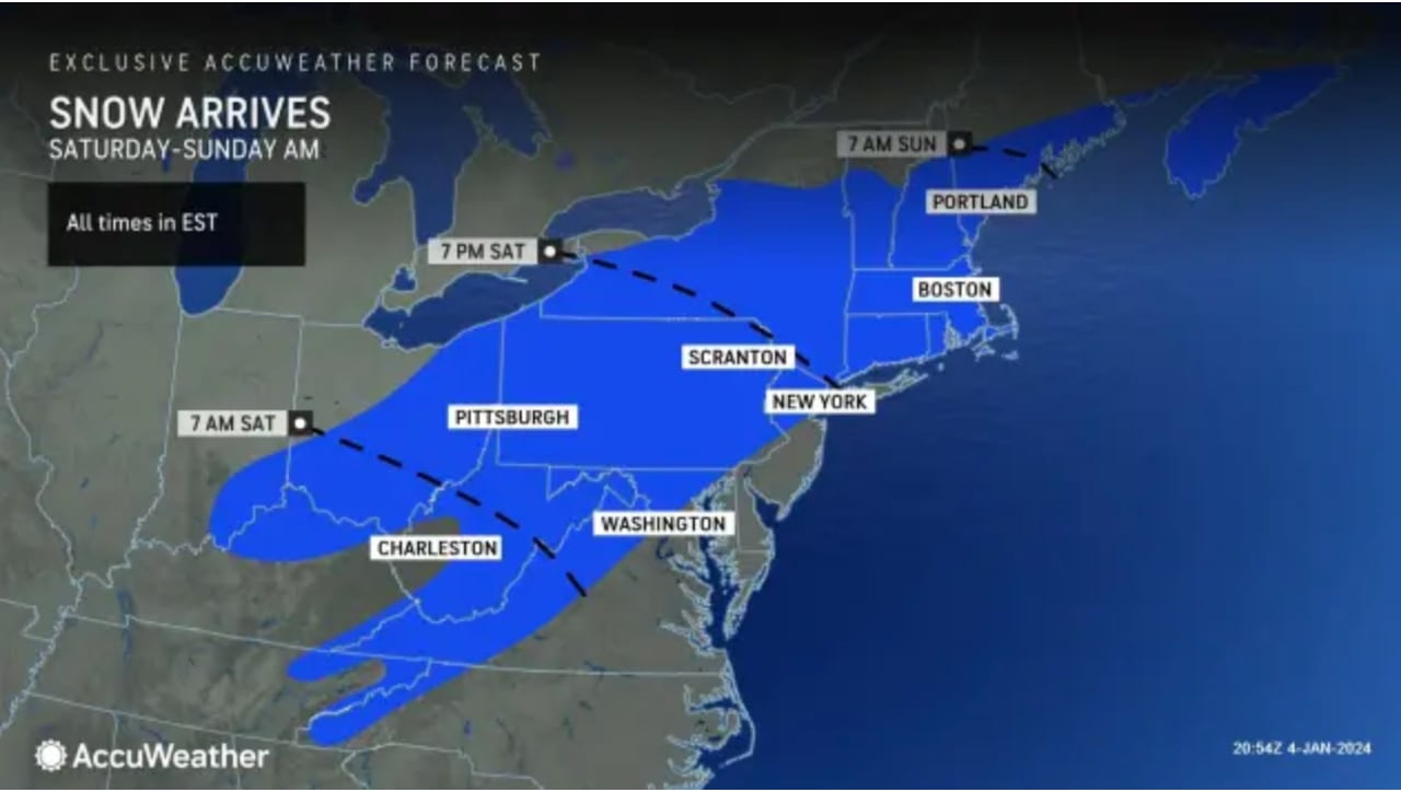
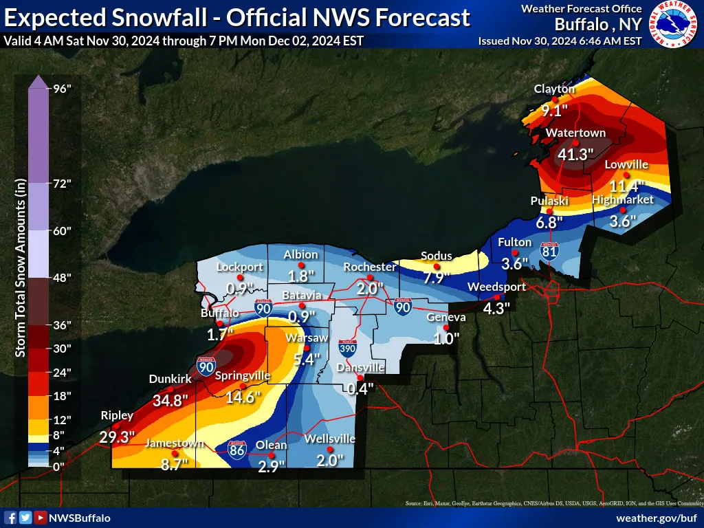
A significant lake effect snow system is impacting Buffalo, New York, and surrounding areas, with heavy snowfall expected through Monday. The snow band is moving northward, targeting Buffalo's southtowns with potential accumulations of up to 2 feet in some areas. Governor Kathy Hochul has declared a disaster emergency, and travel is expected to be difficult due to poor visibility and heavy snow. The snow is also affecting parts of Michigan's Upper Peninsula, with some areas expecting up to 3 feet of snow. Lake Effect Snow Warnings are in effect, advising caution for travelers.
The National Weather Service has issued lake effect snow warnings for parts of Upstate New York, including Western New York and the Tug Hill plateau, predicting "formidable" snow bands that could result in multiple feet of snow and difficult travel conditions. The warnings are in effect from Friday morning through Monday, with the most intense snow expected to fall at rates of 2 inches per hour, accompanied by gusty winds reducing visibility. The snow is driven by cold winds over the warm, ice-free Great Lakes, a common occurrence in late November and early December.
A winter storm is bringing snow to central Maryland, with 1 to 2 inches expected in northern areas and heavier accumulations in the high mountains of western Maryland and West Virginia, where a Winter Storm Warning is in effect. Snow will start by sunrise in southern Pennsylvania and move into northern Maryland, with roads expected to remain wet due to temperatures above freezing. The storm is accompanied by strong winds and is expected to linger throughout the day before clearing by the weekend.
Massachusetts experienced significant snowfall due to a winter storm, with the highest accumulations in Haverhill (13.5 inches), Methuen, and Newbury (12 inches each) in Essex County. Northern Massachusetts and the Merrimack Valley were hit hardest, while southern regions received less. A winter storm warning was in effect through early Monday. The National Weather Service provided detailed snowfall totals for various counties, and updates are expected as the situation develops.
Massachusetts is bracing for a midweek storm that is expected to be more severe than the weekend snowstorm, with potential for heavy rain, strong winds, and coastal flooding leading to widespread power outages and damage. The National Weather Service warns of the storm's impact, which could include over 60 mph wind gusts, and compares it to a late December 2023 storm that caused significant disruptions. Despite the weekend snow, rising temperatures during the week are likely to cause melting and exacerbate flooding issues. A winter storm warning remains in effect, and residents are urged to prepare for the conditions.
New Hampshire is experiencing a significant winter storm with warnings in effect, bringing steady and heavy snowfall expected to accumulate between 6-12 inches in southern and central regions. Difficult travel conditions are anticipated throughout the day due to low visibility and gusty winds. The storm is predicted to wind down by evening, with a return to sunshine on Monday and a brief respite before another system potentially brings mixed precipitation and wind on Tuesday night into Wednesday.
Upstate New York is experiencing its largest snowstorm of the season, with more snow expected before the storm moves out to sea tonight. Central New York has received over 7 inches, with an additional 2 to 4 inches forecasted. The Hudson Valley has been hit hardest, with up to 14 inches of snow. Winter storm warnings are in effect, and hazardous driving conditions are expected throughout the day. A new storm system is anticipated to bring heavy rain and high winds by Tuesday night, raising concerns for power outages and flooding, especially in the Hudson Valley.
New Jersey is bracing for a powerful storm on Tuesday that could bring up to 4 inches of rain, causing potential flash flooding and river flooding due to heavy rainfall and melting snow. Wind gusts may reach 60 mph, especially along the Jersey Shore, leading to possible power outages. The storm is expected to taper off by Wednesday morning, but another storm system is forecasted for the upcoming weekend. Residents are advised to prepare for significant weather impacts.
Massachusetts and southern New Hampshire are experiencing their first significant snowstorm in nearly two years, with a Winter Storm Warning in effect for Sunday. Snow accumulation is expected to vary, with 6-12 inches north and west of I-95 and Route 128, 3-6 inches in areas just northwest of Boston, and 1-3 inches from Boston to the South Shore. Coastal areas may see mainly rain until winds turn northerly. Winds could cause outages in heavy/wet snow areas, and a flash freeze is expected as temperatures drop rapidly in the evening. Another storm is forecasted for late Tuesday, potentially bringing heavy rain and flooding. Cleanup is advised between 4-8 p.m. tonight.
The first significant winter storm of the year is set to hit the East Coast of the U.S., affecting states from North Carolina to Maine with heavy snowfall expected. Winter storm warnings are in place, with projections of 6-12 inches of snow in many areas and over a foot in higher elevations of New England. The storm will bring difficult travel conditions, potential power outages, and minor coastal flooding. Snow is anticipated to start in the New York City area by Saturday evening and continue across the Northeast into Sunday, with conditions improving by Sunday evening.
New Jersey is experiencing a winter storm that began with light snowfall and is expected to bring up to 12 inches of snow to northwestern counties, with heavy rain in the south and a mix of sleet elsewhere. The National Weather Service has issued winter storm warnings and advisories for various counties, advising against travel and urging residents to be prepared for difficult conditions. The storm is anticipated to intensify on Saturday evening and taper off after 2 a.m. Sunday, with Governor Phil Murphy advising residents to stay indoors unless necessary.
A significant winter storm is set to hit the News10 area this evening, bringing heavy snowfall overnight and into Sunday, with 6-10 inches expected in the Capital District and up to a foot and a half in higher elevations. Travel is anticipated to be difficult during the storm. A Winter Storm Warning has been issued. Following the storm, Monday will see calmer weather, but another system arriving late Tuesday could bring a mix of snow and rain, with potential flooding due to melting snow.
New Hampshire is bracing for a significant winter storm with warnings in effect from Saturday night through Sunday night. Meteorologist Kevin Skarupa forecasts at least 6 inches of snow for central and southern parts of the state, with potential for 6-12 inches in some areas. The snow will be heaviest overnight into Sunday morning, affecting travel, especially in southern and central regions. Conditions are expected to improve by Monday with sunshine aiding in cleanup efforts. The snow consistency will vary, with wetter snow in the south and fluffier snow in the north due to colder air. Weather updates will continue as the storm progresses.
The National Weather Service has issued winter storm warnings and advisories for South-Central Pennsylvania, including counties such as Adams, Cumberland, and Dauphin, with expectations of heavy snowfall and mixed precipitation. The warnings are in effect until Saturday evening, with potential travel disruptions and varying snow accumulations across the region. Residents are advised to stay informed and prepare for the incoming winter conditions.
Northern New Jersey is expected to experience a winter storm starting Saturday afternoon, with snowfall beginning between 2 p.m. and 5 p.m. along the Interstate 78 corridor. A winter storm warning is in effect for several counties, with up to 10 inches of snow predicted in some areas. The heaviest snowfall is anticipated to occur from sunset to midnight on Saturday. Light snow may start earlier in the day in some southern counties but with no significant accumulation due to higher temperatures. The storm is expected to transition to light rain or drizzle overnight into Sunday, with minimal additional accumulation.