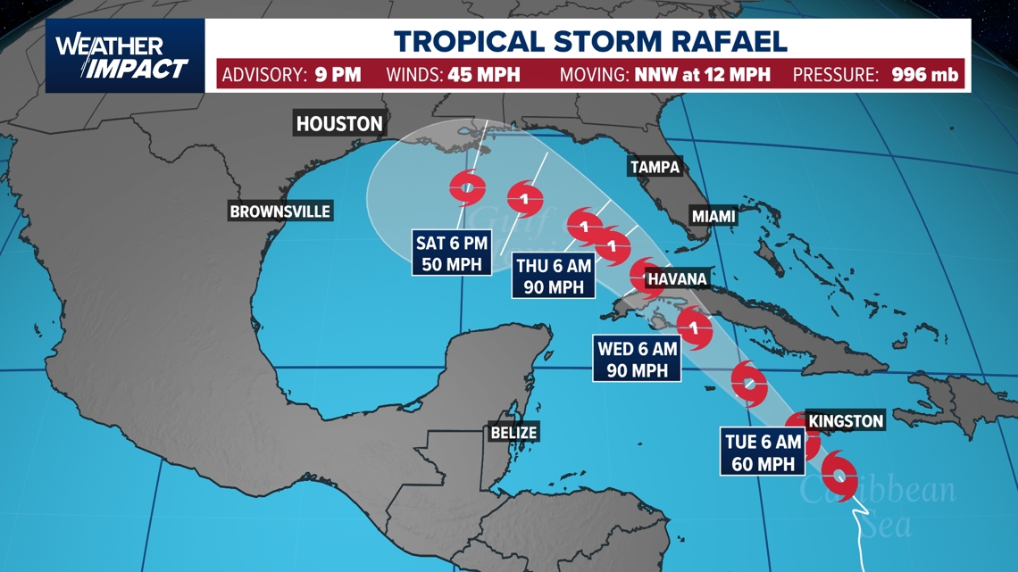
Tropical Storm Rafael has formed in the Caribbean and is expected to strengthen into a hurricane by Tuesday as it moves towards the Gulf of Mexico. The storm is projected to bring hurricane-force winds and dangerous storm surges to the Cayman Islands and tropical storm conditions to Jamaica and possibly the Florida Keys. Although it may weaken due to cooler waters and high wind shear, Rafael could still impact parts of the Gulf Coast. The KHOU 11 Weather Team is closely monitoring the storm's development.
This week in Boro Park, expect cold temperatures in the upper twenties today, dropping to the low twenties overnight with wind chill. Monday will be sunny with a high of 38 degrees, followed by similar temperatures on Tuesday and Wednesday with overcast skies and rain expected on Wednesday. Thursday will bring continued rain and temperatures in the upper forties, while Friday morning will see a wet commute with rain tapering off by afternoon and highs in the upper fifties.
A coastal storm brought significant snowfall to northern New Jersey, with 6 to 12 inches accumulating in some areas, while South Jersey experienced a cold, rainy morning. Central New Jersey saw a mix of wet snow, sleet, and rain, creating a messy situation on roads and in yards.
Several areas in Massachusetts, New Hampshire, Maine, Connecticut, and Vermont have experienced significant snowfall, with some places like Haverhill, MA, and Plaistow, NH, receiving up to 12 inches of snow as of Sunday morning. The National Weather Service has provided a detailed list of snowfall totals across the region, and more snow is expected to follow.
Western Massachusetts experienced significant snowfall this Sunday, with areas like Easthampton receiving up to 11 inches. The article provides snowfall totals for various locations within Hampden and Hampshire counties and offers tips on how to accurately measure snowfall. WWLP-22News, the local NBC affiliate, provides further weather forecasts and updates on their social media channels.
New Jersey is experiencing a quick-moving winter storm expected to bring 6 to 12 inches of snow to northern counties, with the heaviest snowfall occurring Saturday night. The storm is anticipated to taper off after midnight, with some lingering light snow and rain showers into Sunday morning. Winter storm warnings are in effect until Sunday evening for several counties. The state is preparing for potential flooding with another storm system forecasted to bring heavy rain and strong winds by Tuesday, following the snowmelt from the weekend's storm.
Northeast Ohio is expecting a minor snow event over the weekend as a strong storm system passes mainly to the east, with higher impacts anticipated in Pennsylvania, New York, and the northeastern United States. Snow will spread north on Saturday, with scattered snow continuing into Sunday, especially east of Cleveland. Most areas in Ohio will see less than 2 inches, with isolated spots receiving slightly more. No major advisories are in effect, but caution is advised on the roads due to potential slick spots and reduced visibility. Conditions are expected to improve by late Sunday, with dry weather on Monday before another system arrives on Tuesday.
The Metro area is expected to see less snow and more rain as a quick-hitting storm system moves in for the weekend. While the atmosphere is warmer in the Metro and southern areas, reducing the likelihood of snow, northern regions may still experience wet snow with possible minor accumulations. The storm is not anticipated to be major, but it could lead to messy road conditions overnight into early Saturday. The rest of the weekend will be mostly cloudy with chances of rain and temperatures in the 40s.
A weather system is expected to bring a wintry mix to the North Carolina Foothills overnight, with a winter weather advisory in effect for several counties. Meteorologist John Ahrens suggests staying indoors rather than preparing for a major event. Conditions will improve quickly with the wintry mix turning to rain after 8 a.m. and the storm moving out later on Saturday, leading to a calm Sunday. Residents are encouraged to download the WSOC-TV weather app for updates and follow the Severe Weather Center 9 team on Twitter for the latest forecasts.
The Tri-State area, including NYC, New Jersey, Long Island, and Connecticut, is expecting a significant winter storm from Saturday afternoon into Sunday, potentially breaking the region's recent low snowfall records. Forecast models are predicting varying snow totals, with some areas possibly receiving over a foot of snow. Coastal areas should prepare for high winds and potential flooding. The storm's impact will vary by region, with a mix of rain and snow expected in many areas before turning to all snow. Long-term forecasts suggest a pattern change that may bring more snow in the future.
Central PA is set to experience a shift in weather, starting with morning clouds and a stray snow shower, followed by afternoon sun and breezy conditions with highs around 41°F. A winter storm is expected to hit the area on Saturday, bringing snow in the morning that will transition to a wintry mix, especially southeast of Harrisburg, with varying accumulations. The storm should clear by midnight Sunday, leading to a breezy day with a few snow showers. Another system is forecasted for Tuesday, likely starting as snow and sleet but turning to rain with temperatures near 50°F. Stay tuned for further updates as the weekend approaches.
New York City and surrounding areas are anticipating a mix of rain and snow this weekend, with up to 3 inches of snow possible in the metro area, though heavier snow is expected north and west of the city. Coastal regions may experience strong winds and potential minor flooding due to up to 2 inches of rain. The forecast is still uncertain, with more accurate predictions expected later in the week. The rest of the week will be clear but cool, with another storm possibly bringing rain next Tuesday or Wednesday.
The Washington, D.C. metro area is preparing for its first significant snowfall of the season on Saturday, which could be the most substantial snow the area has seen in two years. The storm is expected to start as snow in the morning before transitioning to rain in the afternoon, with the best chances for significant snow accumulations to the north and west of the District. The American model predicts about 1 to 1.6 inches of slushy snow for D.C. before the changeover to rain, marking a notable event compared to the minimal snowfall of the previous season.
The Washington D.C. area may experience its first significant winter storm next weekend, with a possibility of a rain/snow/ice mix as a coastal storm develops. FOX 5's meteorologist Tucker Barnes indicates that while there are many possibilities, snow enthusiasts have a reason to be hopeful. Details will become clearer as the weekend approaches. Meanwhile, New Year's Day in D.C. will be cool and cloudy, with rain showers expected and temperatures in the 40s throughout the week.
Central Pennsylvania is experiencing a weak storm that has brought a mix of rain and snow, with the Laurel Highlands expecting up to 3 inches of snow. A brief respite with sunshine is anticipated on Tuesday, but clouds and snow showers will return by Wednesday night, leading to colder temperatures. The region may see significant snowfall over the weekend, with a potential wintry mix on the following Tuesday and the prospect of an Arctic air mass bringing true winter conditions thereafter. Residents, including the author, are considering putting on snow tires in anticipation of the changing weather.