NASA's TEMPO revolutionizes air quality studies with real-time pollution data from space
TL;DR Summary
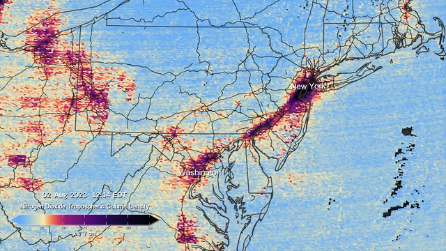
NASA's pollution monitoring instrument TEMPO has released its first data maps, providing researchers with visual representations of pollution patterns and air quality variations across North America. TEMPO, situated 22,000 miles above the equator, offers insights into various pollution sources and is expected to refine pollution studies by providing a deeper understanding of the interplay between human activities and environmental health. This marks the first time air quality over North America is being continuously gauged from space, surpassing previous endeavors in terms of clarity and coverage.
- NASA’s TEMPO pollution monitoring instrument unveils first data maps, revolutionizing air quality studies WSVN 7News | Miami News, Weather, Sports | Fort Lauderdale
- Watch new NASA sensor measure US air pollution from space in real time (video) Space.com
- NASA's new orbiting pollution tracker releases first images of Houston Houston Chronicle
- NASA’s New Air Pollution Satellite Will Give Hourly Updates The New York Times
- NASA's TEMPO sends first North American pollution data maps Yahoo News
Reading Insights
Total Reads
0
Unique Readers
6
Time Saved
1 min
vs 2 min read
Condensed
62%
225 → 85 words
Want the full story? Read the original article
Read on WSVN 7News | Miami News, Weather, Sports | Fort Lauderdale