"Satellite Data Uncovers the Vast, Unseen Industrialization of Our Oceans"
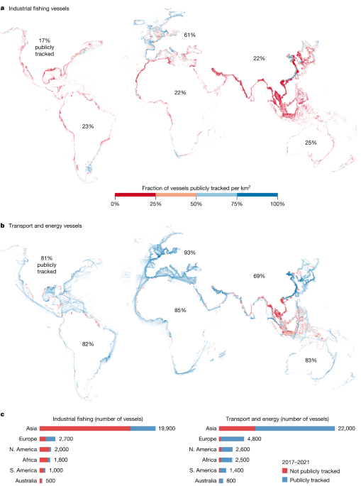
Researchers have utilized satellite imagery and deep learning to create a detailed global map of industrial activities at sea, revealing extensive fishing and non-fishing vessel activity that is not publicly tracked. This study, analyzing 2 petabytes of satellite data from 2017-2021, found that about 75% of global industrial fishing and 25% of other vessel activities evade public monitoring systems. The findings highlight the significant environmental impact of the 'blue economy' and the need for better oversight to ensure sustainable use of ocean resources. The data also show a decrease in fishing activity during the COVID-19 pandemic, contrasting with the stability or growth of transport and energy-related vessel traffic. The study underscores the importance of accurate mapping for managing human activities in the ocean and informs policies on reducing greenhouse gas emissions from maritime industries.
- Satellite mapping reveals extensive industrial activity at sea Nature.com
- Satellite imagery analysis shows immense scale of dark fishing industry TechCrunch
- How crowded are the oceans? New maps show what flew under the radar until now The Verge
- Human activity is powering ‘a new industrial revolution’ at sea, say experts The Guardian
- Most large fishing boats go untracked as 'dark vessels' New Scientist
Reading Insights
0
11
57 min
vs 58 min read
99%
11,556 → 134 words
Want the full story? Read the original article
Read on Nature.com