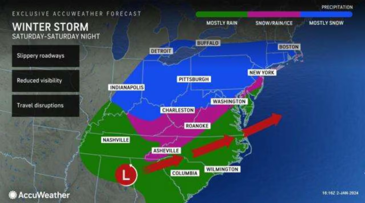
A Winter Weather Advisory is in effect for Hocking, Pike, and Ross counties in the Columbus area from 3 am to 1 pm Saturday, with up to 2 inches of wet snow expected, potentially impacting travel. The weather will transition from snow to a rain/snow mix on Saturday with highs in the upper 30s, followed by a chance of a wet mix on Sunday. The upcoming week will see varied conditions, including mainly cloudy skies, windy and rainy weather on Tuesday, and another potential wet mix by the end of the week.
Denver and other parts of Colorado are expecting several rounds of light snow through the weekend, with a brief pause on Saturday. A stronger system is anticipated to bring more snow Sunday evening into Monday, with potential travel impacts for the Monday morning commute. Accumulations will vary, with less than an inch expected in some Denver areas and 2 to 3 inches in places south of the metro. The snowfall is part of a series of flurries that are helping the region catch up on below-average snow totals for the season, accompanied by colder-than-average temperatures.
The National Weather Service has issued a Winter Weather Advisory for several counties in northwest Arkansas, effective from 4 a.m. to noon on Friday. The advisory warns of potential freezing rain and snow, with up to a couple of inches of snow expected, which may affect the morning commute. Residents are encouraged to download the KY3 First Alert Weather app for updates.
A major winter storm is expected to hit the East Coast, potentially bringing significant snowfall to cities that haven't seen heavy snow in two years. The storm will affect various regions as it moves across the country, with uncertain impacts depending on its path. The I-95 corridor may see a mix of rain and snow, while areas north and west could experience heavier snowfall. Travel disruptions and hazardous conditions are likely, and meteorologists are monitoring the storm's development to provide more precise forecasts.
South-central Pennsylvania is anticipating a winter storm this weekend that could bring plowable snow, marking the first significant snowfall in over a year. While Thursday may see a light flurry with minimal impact, the main event is expected late Saturday afternoon through Sunday, with potential for heavy snowfall Saturday night. Mixed precipitation is also possible, particularly in southeast counties. Residents are advised to prepare for travel disruptions and stay updated with the WGAL News 8 Storm Team's tracking of the systems.
New York City is expected to see the end of its 688-day snow drought this weekend as a winter storm is forecasted to bring over an inch of snow starting Saturday night. AccuWeather Meteorologist Alex DaSilva notes the potential for several inches of snow, although exact totals are uncertain due to the proximity of warm ocean water. The storm may start with snow, switch to rain, and then back to snow, with the possibility of slush accumulation on roads. Gusty winds are expected but not likely to cause widespread power outages. The storm is predicted to taper off by Sunday afternoon, and another system could bring more precipitation around January 9th and 10th.
Denver is preparing for its first snowstorm of 2024, expected to hit late Thursday and move out by Friday morning. The Pinpoint Weather team forecasts a temperature drop and snow accumulation across Colorado, with varying totals from a dusting in Denver to up to 6 inches in mountain towns. The storm's center will likely stay south, affecting travel, especially on Thursday evening and Friday morning. Residents are advised to stay updated with the forecast as conditions may change.